Scenic Southern Syunik
- (0)

Between heaven and earth lies the majestic Mount Khustup, towering 10,500 feet and watchfully guarding the southernmost Armenian province of Syunik.
Each corner of Armenia has its unique magical aura, bridging the timeless thousand-year-old ruins of fortresses and breathtaking churches to the local inhabitants on a backdrop of a vibrant landscape and colorful fruits. There is no doubt that visitors to the countryside have filled their lungs with air rich with stories dating back hundreds of years.
The province of Syunik is part of this enchanting landscape that has drawn me into its loving embrace over the past few years. The region’s awe-inspiring jagged peaks are only rivaled by the famous Mount Ararat. Most travelers venture to the German-designed city of Goris and the ninth century Tatev Monastery, but very few venture deeper into the mountainous expanse because of the intimidating winding roads and distance from the modern trappings of Yerevan.
The route leading south is brutally rugged. One cannot help but imagine the proto-Armenians that first traversed these highlands like Otzi of the Italian Alps, seeking the perfect location to settle and build a mountainous refuge far from raiders and rival tribes. Off to the left and right of the meandering highway, villages can be spotted nestled in deep gorges and perched on the slopes of the Zangezur mountain range. Most are still self-reliant communities that grow their own produce, graze their own livestock and build their own houses one brick at a time. To a California mountain climber like myself, who prides himself on reaching remote valleys and summits in the Sierra Nevadas, Syunik’s skyscraper peaks feel like home. Having traveled through its massifs several times, I must admit there is nowhere else in Armenia quite like it.
Since the 2020 Artsakh War, access into southern Syunik has become more difficult due to the hostile closure of the M2 highway connecting Goris to the provincial capital of Kapan. Movement to and from the city is now mainly along the newly-renovated, serpentine H45 road which is in rough condition and an arduous two-hour journey. The city of Kapan hugs the banks of the Voghji River with Mount Khustup in its backdrop. Soviet-era gray buildings dominate the cityscape which house much of the workforce for the largest mine in Armenia, the Kapan Copper-Molybdenum Combine.
Halidzor Fortress is a recently renovated landmark sitting on a hilltop just outside the city limits of Kapan. It is an ancient complex turned into the headquarters of the legendary Armenian commander David Bek tasked to protect the region against an onslaught from the Ottoman Empire in the early 1700s. While many of Armenia’s old fortresses are in ruins, Halidzor is a stunning showcase of one that has been restored. The site of a historic battle where David Bek and his few hundred fighters fought off thousands of invading troops (The Armenian 300) makes this fortress a must see.
Further south, the famous cascading waterfalls of Lichk village are rarely visited and never mentioned in any Armenia tourism guides. A local villager told us that during the Soviet era, tourists would visit Lichk for backcountry skiing expeditions. His accent was reminiscent of Western Armenian which soothed our ears as he shared raspberry picking techniques in his garden. The village’s surrounding region is designated as one of only a handful of PBAs (Prime Butterfly Area) in Armenia, home to dozens of unique species of butterflies. There are no hotels in the area. The town has a population of 161 with a single general store.
Straddling the northern bank of the Arax River demarcating the Iran-Armenia border is my favorite provincial town of Meghri. Originally named Karchavan in 906 AD by the Armenian King Smbat I of the Bagraduni Dynasty, the city was incorporated into the Kingdom of Syunik in 987 AD as Meghri (Honey Town). The city is home to the ruins of the 11th century Meghri Fortress and three beautiful churches dating back to the 16th-17th centuries. While the fortress is abandoned and dilapidated, the churches are well-maintained and adorned with detailed frescos reminiscent of Vank Monastery in Isfahan, Iran. Homes in the town are loosely packed, with lush gardens that produce every fruit known to grow in the Armenian highlands. When you mention “fig” in Armenia, people think of Meghri. In July, the fig trees are so full that the villagers welcome passersby to pick several so they are not wasted. Consider it a public service.
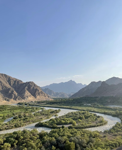
All Armenians have heard of the Arax River—the legendary waterway that feeds the Eastern Armenian Highlands and constitutes modern-day Armenia’s western and southern borders. While the Arax is restricted on the Turkish side, on the Iranian side you can find yourself just 50 feet away from it. A Soviet-era fence still restricts direct access to the river, but the views are uninhibited from quite a few vantage points. The ultimate view is from Giorgi Babi’s cottage near the Meghri Train Station. The brown and barren mountains the Arax cuts through remind me of the Colorado River in the Southwest United States. It didn’t take long for us to play country music during our joy rides around town, enjoying the view of the wild horses running freely in the hills and feeling like cowboys in the Wild West.
If you look at a map of Armenia as a human head, southern Syunik is the all-important neck—a pedestal on which the head is anchored with pride and confidence. A section of our motherland’s main artery—the North-South Highway—travels through Armenia’s heartland carrying much-needed resources and materials. On the back of this neck now stands the Turkish yataghan ready to strike. The Diaspora’s responsibility is to reinforce Syunik with tourism, investments and philanthropic endeavors. As the famed military commander and Prime Minister of the Republic of Mountainous Armenia Karekin Njdeh once said, “Anywhere without Syunik and Artsakh…without this strong geographic spine of Armenia, our holistic homeland cannot exist.”
Dr. Raffi Dadaian
The Armenian Weekly


